Our Kurinjal trek in September was in a
small group of four people and I was keen to go for another western ghat trek
in the larger group. It took talking to some members of the WhatsApp group and
the number went up to fifteen. We had new members as well as some returning
after a long gap.
Hari as usual kept the place a secret and
we decided to go for the trek on the weekend of December 18-19. People who
joined the group were: Hari, Guruprasad, Gururaj, Sujith, Pramod, Chinmay,
Yatish, Vinayak, Renukumar, Vishal, Manish, Pratap, Varadarajan, Rishi and I.
Rishi was the youngest, and had replaced his father Raju who couldn’t join.
For introduction, Merthi Gudda (Merthikhan
Gudda or Meruthi Gudda) is a part of the Kuduremukha mountain range in the
western ghats near Kalasa in Chikmagalur district of Karnataka. This is 1,676 m
(5,499 ft) tall peak adjacent to Ane Gudda (1346 m, 4,415 ft), Kuduremukha (1,894
m, 6,214 ft) and Kurinjal (1159 m, 3800 ft). The base camp is Basarikatte (ಬಸರಿಕಟ್ಟೆ) village in
Koppa Taluk.
The list of things to carry and time of
pickup were shared. On Friday night starting 22:00, we got picked up from PES
college stop to Gurgunte palya stop. I had a long wait at Laggere ring road
where I had to bear the strong smell of kababs emanating from a roadside pushcart
shop that had a brisk business. The vehicle was a 21-seater spacious bus. The
destination was announced as Merthi Gudda while we all were on the bus and Renu
circulated a nice drone video of the hill. Around 0:30, we stopped for
tea-biscuits and took a group picture. The journey was comfortable though many
of us couldn’t sleep well. It was 6:50 when we reached the homestay. It was
quite an effort as our bus could go only up to Samse, from where we were picked
up in a 4x4 vehicle by Narayananna and taken to “Uttunga’ homestay through a
roller coaster drive. The homestay is certainly one of the best we had ever
seen, with very comfortable rooms and stunning view of the valley and hills.
Unfortunately, the homestay is far away (33 kms) from Basarikatte, thus adding
a couple of hours in getting to start the trek. Staying either at homestays in Badanekhan
or Jainkhan estates would be ideal for this trek, but Hari couldn’t find a
place that could accommodate 15 people on that weekend. Nevertheless, the
homestay was indeed excellent, and the hosts were very hospitable.
At a tea stall on the way
View from Uttunga homestay
Breakfast
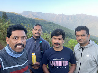
Team ready
With Narayan anna
Tea estate
Ganesha temple at Samse
On the way to Basarikatte
Start of the trek
Basarikatte
We had breakfast of idli and upma at 8:30
and left the homestay at 9. We were dropped to Samse by the 4x4 vehicle where
we took our bus to reach Basarikatte. It was 10:30 when we reached Basarikatte.
Here we met out guide Surendra. We started walking on the concrete road and
within few minutes had to climb and cross barbed wire fence. It took some time
for all of us to cross. Then we started walking uphill next to the fence for
some time. The trail was nice through a canopy of trees and reached a grassland
from where we could see the views of both the town below and the hill in front.
The walk uphill was mostly on the ridge. On the way we had couple of photo
opportunities. In the second spot, I and Vinayak waited for about half an hour
Pramod, Chinmay and Sujith to catch up. We then proceeded in the last phase of
the climb to reach the peak. There is Ganesha idol in a small mantapa. A
Karnataka flag also adorns the mantapa. There was another group of trekkers on
the peak who offered us some girmit (bhel). They were going to go down, stay
and watch Kambala. It was 14:00 by the time we joined our group. We had our
packed lunch. As most of us had given big boxes for filling the lunch. We were
having too much food with us, that we couldn’t finish. The 360o view
from the peak was breathtaking. We spent some time clicking pictures. On the
way down we were to get down to Horanadu. Surendra, our guide was in a hurry to
go down as he had to catch the last bus from Horanadu to Basarikatte.
Crossing a barbed wire fence in the beginning
First view
Town
Ridge walk
At a stop
At the top
We started coming down around 14:50.
Earlier idea was to climb Ane gudda and get down to Horanadu, but looking at
the time, it wasn’t feasible. Surendra said walking through the estates was
shorter, but sometimes the owners may object. However, we didn’t face any such
issue on the way. Once we came down, we realized that we were exactly between
Basarikatte and Horanadu. While some of us walked to Horanadu, others took a
drop by the jeep that Hari arranged. At Horanadu, we had our vehicle waiting
for us. It took half an hour to reach Samse where we were picked up by the 4x4
vehicle and reached the homestay by 19:30. We freshened up and had the usual
karaoke session followed by dinner.
Sunaset
Next morning Guruprasad, Renukumar, Hari
and I went for a trek behind the property to see the sunrise. The trail was
steep and slippery in some places. We walked about 2.5 kms to a place called
Banikonda where couple of houses were there. The view all around was beautiful and
we witnessed sunrise on the hills at 7:30. We met a local farmer who talked
about the difficulties of living in these remote places. They grow rice on the
slopes of the hills by the way of step farming. The ground was prepared by
their forefathers long ago.
Morning trek
Rice fields. Kuduremukha in the background
It was almost 9:00 by the time we returned
to Uttunga. The breakfast of paddu and shavige baat was ready. We finished the breakfast
and got ready to leave. It was 10:30 by the time everyone was ready, and we got
a drop by the four-wheel drive to Samse. Next, we decided to go to Abbakudige
where Soormane falls was located. It was earlier known as Abbukudige (or
Abbugudige) falls created by Bhadra river. It was at a distance of 14 kms
covered in 30 minutes. The last bit was through a single road. Private people
provide car parking a collect money. The view of the falls was breathtaking and
access to the bottom wasn’t very difficult. The time under the heavy shower was
very refreshing. We spent about half an hour there and returned to our vehicle.
Once again, I feel it is high time our government cares for these places and
develops them as good tourist spots. It will be more organized, and the government
will earn a revenue.
Breakfast
Soormane falls
On the way back, we started looking for a
place for lunch, but many restaurants were closed due to Datta Jayanti. Yati felt
that Goddess Annapoorneshwari is unhappy as we didn’t do her darshan (!).
Finally, we found a place close to Hassan for non-vegetarians, and sometime
later a restaurant in Hasan for vegetarians. The traffic back home was heavy,
and we reached home late.
Sunset on the way back
It was a wonderful trek with nature’s
abundance and the pleasant company of friends made it more memorable. The Uttunga
home stay, though was not near to the trekking start point, was certainly one
of the best on terms of view and comfort.